Population resilience to flood risks in the context of climate change: what adjustments of humanitarian actions to socio-ecological systems in Ziguinchor (Senegal)?
The general objective of this study is to analyze the vulnerability of the populations of the city of Ziguinchor in order to determine their level of resilience in the face of flood risk.
Feeding prevention and risk reduction strategies in the face of floods
This research project addresses the prevention and protection behaviors of populations in the face of recurring floods in Ziguinchor. It seeks to document the sociocultural determinants that influence the adaptation capacities of the populations of Ziguinchor in order to allow stakeholders to integrate them into their prevention and risk reduction actions, and to enable populations to become actors in their own security. This research therefore answers the dual question: what are the causes of population fragility and the factors of the resurgence of floods in a context of climate change in the city of Ziguinchor? How do populations perceive flood risks and what is their level of vulnerability to such risks in the city of Ziguinchor?
The study of the determining physico-geographical characteristics in risk prevention
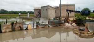
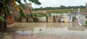
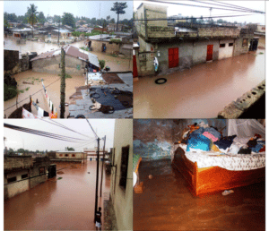
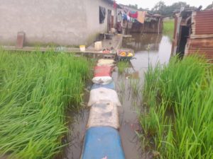
The districts where vulnerability to flooding is most pronounced have as a common denominator: a very low topography, the sub-outcropping nature of the water table and the presence of hydromorphic soils (therefore more or less clayey). Built mainly on a lowland site, the city of Ziguinchor has been living for several years under the rhythm of floods whose negative impacts are clearly perceptible, especially in the districts with low topography.
In order to study the physico-geographical characteristics of the site – which are a determining factor in understanding the manifestation of floods – the research process takes place in three phases, a first phase of identifying perceptions of risk and vulnerability; a second of describing the flood risk; and a third of calculating the level of vulnerability. The methodology of this research project is based on direct observations in the field as well as surveys and interviews.
This approach is supplemented by diachronic analyses of the images in order to produce land use maps, vulnerability maps and ravine maps and the proposed water evacuation plan.
Strengthening the state of knowledge and drawing inspiration from promising local practices
The literature on the factors behind the increase in floods, how populations perceive these flood risks and what their level of vulnerability is to such risks suffers from certain gaps. This research therefore aims to contribute to strengthening knowledge on this subject while documenting promising practices in terms of strengthening resilience to flooding in urban areas. Thanks to the participation of various local actors, it seeks to list the institutions of use and useful forms of traditional knowledge to cope with climate change and the recurrence of flooding phenomena in urban areas.
Biography
A PhD in Geography from Anta Diop University in Dakar, Cheikh Faye is now a lecturer and researcher in the Department of Geography at Assane Seck University in Ziguinchor. Specializing in Hydrology, he is mainly interested in the dynamics of the flow of West African rivers (Senegal, Gambia, Casamance, Kayanga, etc.) in the face of variability and climate change.
He is also the author of numerous articles and five books: Characteristics of drought in Senegal, Editions Universitaires Européennes, 2017; Climate change in the Senegal River basin, Edilivre, 2019; What statistical methods are used in the geographer’s approach, TheBookEdition.com 2019; Water territories in Senegal, Les Éditions Chapitre.com 2019; Characteristics of COVID-19 in Senegal, Les Éditions du Net, 2021.